
31. Dezember 2014
20. November 2014
Mountain Gorillas: They Share 98% of Our DNA / Die Berggorillas: 98% gleiche DNA wie wir Menschen
 |
| Silverback Ndungutse, member of the Nyakagezi gorilla group in the Mgahinga Gorilla NP, Uganda Silberrücken Ndungutse aus der Nyakagezi Gorilla-Familie im Mgahinga Gorilla Nationalpark, Uganda |
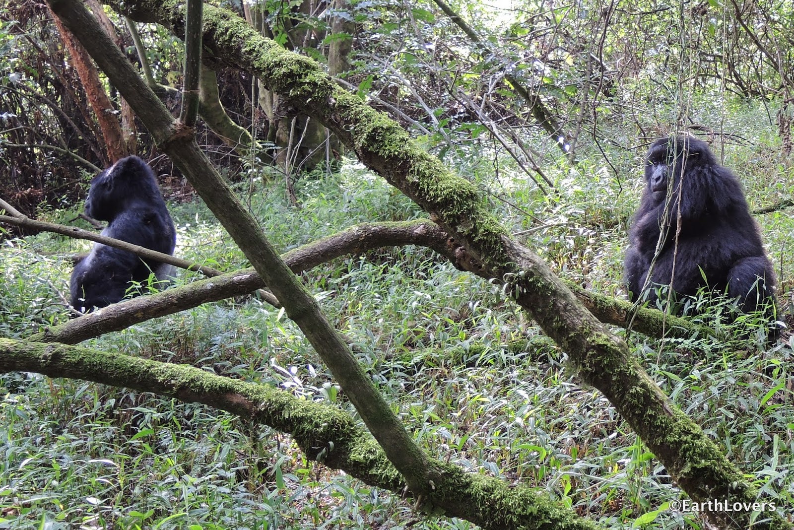 |
| A silverback and a juvenile of the Nyakagezi gorilla group Ein Silberrücken und ein "Teenager" aus der Nyakagezi Gorilla-Famile |

Did you know?
- The DNA difference between the gorilla and homo sapiens is just about 2%.
Thus it's not surprising that seeing the gorillas in their natural habitat is such a unique, unforgettable experience for us humans. - They have a lifespan of 30-40 years in the wild.
- There are roughly about 700 mountain gorillas (according to National Geographic) remaining on Earth, means they are critically endangered.
- Half of the world's remaining mountain gorilla population lives in the Virunga Mountains of Central Africa, at the intersection of Uganda, Rwanda and the Democratic Republic of the Congo. The other half lives just 24 km north of the Virunga Mountains, in Uganda's Bwindi Impenetrable National Park.
- You can do a gorilla trekking and see them in their natural environment - well, not all of them, since "just" 26 gorilla families are habituated to human presence.
- The rule: there is just one group of max. eight visitors allowed to visit one gorilla family per day...
- ... and for just one hour (there should not be too much contact with humans. Moreover gorillas are vulnerable to our diseases, since they have 98% of our genes. Hence you are not allowed to visit them if you are sick, and be it just a flu, for even this can be fatal for gorillas.)
- that is: max. 178 visitors = permits per day in all three countries (Uganda: 72, Rwanda: 80, DRC: 26)
- The price for a permit is USD600 in Uganda and DRC, in Rwanda even USD750. But it is good value! Aside from that the fees also benefit gorilla conservation.
Some more general information about the gorillas?
Great organization: Gorilla Doctors
National Geographic: "Virunga Gorillas"
BBC: "My other children, the orphan gorillas of Virunga"
The Dodo "Can One Documentary Save The Last Of The Mountain Gorillas In Virunga?"
Guide to Gorilla Trekking in Africa's Rainforests

 |
| Gorilla Doctors, a great Mountain Gorilla Veterinary project Gorilla Doctors, ein tolles Tierärzte-Projekt für die Berggorillas |
Die Berggorillas: 98% gleiche DNA wie wir Menschen
Habt ihr das gewusst?
- In nur 2% der DNA unterscheidet sich der Gorilla vom Homo Sapiens. Kein Wunder, dass ein Besuch bei ihnen für uns Menschen ein einmaliges, unvergessliches Erlebnis ist.
- Sie haben eine Lebenserwartung von 30 - 40 Jahren in der Natur.
- Es gibt nur noch ca. 700 Berggorillas (Zahlen von National Geographic) in der Welt - sie sind daher vom Aussterben bedroht.
- Sie leben ausschließlich in einem kleinen Gebiet Zentralafrikas: die eine Hälfte in der Virunga-Gebirgskette im Dreiländereck Uganda, Ruanda und Demokratische Republik Kongo, die andere Hälfte im nur 24 km nördlich der Virunga Berge gelegenen Bwindi Impenetrable National Park in Uganda.
- Man kann sie beim sog. Gorilla-Trekking in ihrem natürlichen Umfeld erleben, genau genommen nicht alle, sondern "nur" 26 Gorilla-Familien; die anderen bleiben ohne Kontakt zu Menschen.
- Die Regel: zugelassen ist nur 1 Gruppe mit max. 8 Besuchern pro Gorilla-Familie pro Tag...
- .. und für lediglich 1 Stunde (Sie sollen nicht zu sehr an Menschen gewöhnt werden. Außerdem sind sie aufgrund der 98%igen Verwandschaft mit uns leider auch sehr anfällig für unsere Krankheiten. Daher darf man sie nicht besuchen, wenn man krank ist. Das gilt auch schon für eine Erkältung, denn bereits sie könnte fatal sein für Gorillas.)
- Das bedeutet: max. 178 Besuche = Permits pro Tag (Uganda: 72, Ruanda: 80, DRC: 26)
- Ein Permit kostet inzwischen USD600 in Uganda und der DRC, in Ruanda sogar USD750. Doch ehrlich: Es lohnt sich jeder Dollar! Außerdem kommt das Geld auch dem Erhalt der Gorillas zugute.
Wollt ihr noch mehr über Gorillas wissen?
"Dian Fossey - Leben mit den Gorillas - Berggorillas in Not"
Bayerischer Rundfunk: "Gorillas sind akut gefährdet"
Zeit-Online "Virunga-Nationalpark: Keine Ölförderung im Wald der Berggorillas"
Rettet den Regenwald e.V. "Erfolg für die Berggorillas"
Blog: "Mgahinga Gorilla Nationalpark - Gorilla-Reisen in Uganda"
Großartige Organisation: Gorilla Doctors (englisch)
18. November 2014
What is the Fastest Way to the Gorillas? / Wie kommen wir am schnellsten zu den Gorillas?
 |
| YEAH, once more an Equator crossing! Here in Uganda close to the Queen Elizabeth NP JAAA, wieder eine Äquator-Überquerung! Hier nahe des Queen Elizabeth Nationalparks |
 |
| The red soil of Africa. I just love it! Die rote Erde Afrikas. I just love it! |
 |
| A Pied Kingfisher in the evening sun Ein Graufischer in der Abendsonne |
Finally, finally it was going to happen! Our next destination: the mountain gorillas, the clear no. 1 on my 'bucket list' for our Africa Tour. Beforehand I already read several books about these majestic, unfortunatelly critically endangered animals. They are the second-closest relatives of humans after chimpanzees. Of course we had also watched 'Gorillas in the Mist', the moving story of Dian Fossey, an American scientist who came to Africa to study the vanishing mountain gorillas, and later fought to protect them. I was very excited.
Lengthwise across Uganda at one go
First, we had to drive from the north of Uganda to the southwest of the country. We went along the western border of Uganda, close to the Democratic Republic of the Congo (DRC), from Lake Albert past the Rwenzori Mountains (with Africa's third highest peak), between Lake George and Lake Edward towards Kabala and the Lake Bunyonyi: 670 km, which are about eleven hours to drive.
We made two overnight stops. The first one was at the campsite of Kluge's Guest Farm in the south of Fort Portal. The German Stefan Kluge has built a spacious botanical oasis, including even a small tropical rainforest, the home for several families of monkeys. Together with his charming wife Mariam he spoils the guests with excellent food, e.g. fresh vegetables from the own garden and home-made bread. Recommendable! The second night we made a stop at the Simba Safari Camp: nothing spectacular, but close to the gate of the Queen Elizabeth National Park.
Free drive through the National Park
Yes, you are reading correctly! Free of charge. And officially. "How does it work?", you might ask yourself. Well, it is quite easy. You just take the transit route through the national park. You are not allowed to pull of that route though, but this we had not in mind anyway. In case you are around the area one day: behind Katunguru you turn right towards Lake Edward, then southwards through the Kigezi Wildlife Reserve and past the sightseeing 'Tree Climbing Lions' - alas for us just an empty promise on that day. Then left to Kihihi and Kagungu (from there beautiful scenic route) and further on to Kabale and the Lake Bunyonyi. There I wanted to arrange the permits for the gorilla trekking.
Don't be talked into it!
You can read it everywhere: Permits for the gorilla trekking have to be booked months in advance. Of course we could not do that, since we didn't know before at what particular date we would come to the gorillas. Hence only on site I was sending out a request via email to six different tour operators, asking for permits for the next day. Guess what! Each of them had permits available, even the park office in Kisoro. So please, don't be talked into it, should you decide one day to also see the gorillas.
 |
| Tea plantation in the west of Uganda Eine Teeplantage im Westen Ugandas |
 |
| This will be black tea one day Das wird einmal schwarzer Tee |
 |
| Luckily most bicycles here have solid robber tyres. They are puncture-free. Nur gut, dass die meisten Fahrräder hier Vollgummireifen haben. Die sind pannensicher. |
 |
| Fort Portal, a town close to the Rwenzori Mountains, which are also called the "Mountains of the Moon" Fort Portal, eine Stadt in der Nähe der "Mondberge", wie das Ruwenzori-Gebirge auch genannt wird |
 |
| On the road somewhere in Western Uganda Unterwegs irgendwo im Westen Ugandas |
 |
| Typical for the area: hills... Typisch für die Region: zahlreiche Berge... |
 |
| ... with terrace gardens, ... ... und Terrassenanbau, ... |
 |
| ... and this, too: surface-mining ... und auch das: Rohstoff-Gewinnung im Tagebau |
Wie kommen wir am schnellsten zu den Gorillas?
Endlich, endlich war es soweit! Unser nächstes Ziel: Die jahrelange Nr. 1 auf meiner 'Bucket-List' für unsere Afrika-Tour - die Berggorillas! Im Vorfeld hatte ich bereits mehrere Bücher gelesen über diese majestätischen und leider akut gefährdeten Tiere, die nach den Schimpansen die nächsten Verwandten des Menschen sind. Natürlich hatten wir zuvor auch Gorillas im Nebel gesehen, die bewegende Verfilmung des Lebens der amerikanischen Gorilla-Forscherin Dian Fossey. Ich war schon sehr aufgeregt.
Einmal längs durch Uganda
Zuerst einmal mussten wir jedoch vom Norden Ugandas bis in den Südwesten des Landes fahren. Wir wählten die Strecke durch den Albertgraben, entlang der Westgrenze Ugandas zur Demokratischen Republik Kongo: vom Lake Albert am Ruwenzori-Gebirge (dritthöchstes Gebirge Afrikas) vorbei, zwischen dem Lake George und Lake Edward entlang nach Kabale und an den Lake Bunyonyi. 670 km, für die man knapp elf Fahrstunden einrechnen muss.
Zwei Übernachtungen hatten wir unterwegs. Die erste war auf der Campsite von Kluge's Gästefarm, südlich der Stadt Fort Portal. Der Deutsche Stefan Kluge hat hier eine sehr gepflegte, weitläufige Oase geschaffen, eigentlich eher eine Parkanlage, die sogar einen eigenen kleinen Dschungel mit Affen umfasst. Gemeinsam mit seiner charmanten Frau Mariam verwöhnt er die Gäste auch kulinarisch, u.a. mit selbstgebackenem Brot und frischem Gemüse aus eigenem Anbau. Empfehlenswert! Die zweite Nacht standen wir im Simba Safari Camp: nichts Besonderes, aber nahe am Gate zum Queen Elizabeth National Park.
Kostenlose Fahrt durch den Nationalpark
Ja, ihr lest richtig: kostenlos. Und ganz offiziell. "Wie geht das denn?", fragt ihr euch jetzt bestimmt. Ganz einfach. Man nehme die Transitstrecke durch den Nationalpark. Dafür darf man zwar nicht von dieser Strecke abweichen. Das hatten wir allerdings eh nicht vor. Falls ihr mal in der Nähe seid: Die Route geht hinter Katunguru rechts ab Richtung Lake Edward. Dann weiter südwärts durch das Kigezi Wildlife Reserve und am Sightseeing 'Tree Climbing Lions' vorbei - für uns an dem Tag leider nur ein leeres Versprechen. Dahinter links ab über Kihihi nach Kagungu (ab hier sehr schöne Strecke) und weiter über Kabale zum Lake Bunyonyi. Dort wollte ich mich um die Permits für das Gorilla-Trekking kümmern.
Lasst euch nichts erzählen!
Überall liest man, die Permits fürs Trekking der Gorillas müssten Monate im Voraus gekauft werden. Das war für uns natürlich nicht möglich. Denn wir wussten ja nicht, wann wir auf unserer Tour zu den Gorillas kommen würden. Also startete ich vor Ort per Email eine kurzfristige Anfrage für den nächsten Tag bei sechs verschiedenen Tour-Anbietern. Und siehe da: Alle hatten noch Permits im Angebot. Selbst im Park Office in Kisoro gab es noch einige. Lasst euch also nicht verrückt machen, solltet ihr selber einmal eine Tour zu den Gorillas planen.
 |
| On the transit route in the Queen Elizabeth NP Auf der Transitstrecke im Queen Elisabeth Nationalpark |
 |
| Lake Bunyonyi in south western Uganda Der Lake Bunyonyi im Südwesten Ugandas |
 |
| The Bunyonyoni Overland Resort |
 |
| ... offers a perfect campsite, right on the lake shore ... bietet eine perfekte Campsite, direkt am Seeufer |
 |
| Does every caterpillar... Wird eigentlich aus jeder Raupe... |
 |
| ... turn into a butterfly? (No, some turn into moths; -) ) ... zwingend ein Schmetterling? (Nein, manche werden auch Motten ;-) ) |
3. November 2014
At the Murchison Falls: Why Were We Offering Such a Funny Sight? / An den Murchison Falls: Warum boten wir so einen komischen Anblick?
 |
| The famous Murchison Falls Die berühmten Murchison Falls |
 | |
| Greeted by a gentle giant Ein sanfter Riese |
 |
| A black-and-white colobus - clearly a male one ;-) Ein schwarz-weißer Stummelaffe - eindeutig ein Männchen ;-) |
 |
| Pied kingfisher, sitting on elephant dung Der Graufischer genießt eine kurze Pause auf dem Elefantendung. |
 |
| Magnificent waterbuck Prachtvoller Wasserbock |
The Northwest of Uganda offers a breathtaking sight: the famous Murchison Falls. Here the waters of the world's longest river Nile - at this point about 200 meters wide - squeeze through a narrow gorge, only six meters wide, before dropping about 40 meters below. That is really spectacular. Yet our adventure there was even a bit more spectacular. But first things first.
Thanks to the recommendation of other travellers we went to the Murchison River Lodge nearby the Murchison Falls National Park. The complex is beautifully located on the Nile with an excellent view from the open restaurant to the river, with good food and great service. Even the campsite, though without direct view to the stream, is generously sized and layed out nicely.
Scenic highlight
Elise, the very friendly and helpful manager, organized a boat for us which should bring us into the national park. We wanted to go to the Murchison Falls, the scenic highlight of Uganda's largest national park, about 20 kilometers upstream. Of course we also wanted to take the 45 minutes hike to the top of the falls.
Well, we started driving along the opposite bank of the Nile and enjoyed the diverse wildlife, when after a stop our guide could not restart the engine of our boat. Oh dear! Luckily we were within network range. A little later - or even a bit longer - he got a spare boat from one of his colleagues. We could continue our ride, but our guide moved forward very slowly.
Rain clouds or bush fire?
From time to time Martin and I were gazing into the distance, where we suspected the waterfalls. We were concerned about the grey clouds in the sky. This we also told our guide. But he played it down. We shouldn't worry about them - they would be signs of a bush fire, no rain clouds at all. First he wanted to show us the wildlife, only later the falls. However, since these clouds were getting darker and darker, we insisted at a certain point to go to the falls first. And what shall I say? All of a sudden the guide was expecting intense rain, and he discouraged us from going there any more. Nah! Now more than ever, in fact as quickly as possible.
Tcha, thus Martin and I were climbing the banks of the Murchison Falls. Without any required ranger, for they already edged away, but with amazing speed. We wanted to be faster than the rain. And we succeeded. At least for half of the route. Then all of a sudden heavy gusts of wind were getting up, and the rain was bucketing down. Moving along was impossible. We became soaking wet within seconds. (Alas our little camera was also affected by the water, and later on we could only dispose of it.) Carefully we climbed down and seeked shelter under some trees. Even though it was really unpleasant to be standing there completely soaked, we suddenly had to laugh out loud. The situation was just too funny.
 |
| Sky at the start of our boat trip Himmel zu Beginn unserer Bootsfahrt |
 |
| Rain clouds or bush fire? Regenwolken oder Buschfeuer? |
 |
| Bush fire? Good joke, hey! Buschfeuer? Von wegen! |
 |
| Murchison Falls: dramatic atmosphere! Shortly before... Murchison Falls: dramatische Stimmung! Kurz bevor... |
 |
| ... the rain was bucketing down ... es wie aus Kübeln schüttete |
Valuable tool even in Africa
When the lashing rain stopped, we drove back to the lodge. Unfortunately we did not have any spare clothing on board. Although Martin put his arm around me, I was and stayed cold. Fortunately we always have a hot-water bottle in the camper. Yes, even in Africa you need it every now and then!
When I am now thinking of the Murchison Falls, I often have to smile. Cause I clearly remember us standing there in the rain, and we looked like ... well, let's face it: we simply looked crestfallen.
 |
| Curious colobus-baby Neugieriges Colobus Äffchen |
 |
| Where is the object of desire? Wo steckt das Objekt der Begierde? |
 |
| Wistful expression Wehmütiger Blick |
 |
| Great lookout Großartiger Ausguck |
 |
| Waterbuck female with offspring Wasserbock-Weibchen mit Jungem |
 |
| Hartebeest on the hop Kuhantilope auf dem Sprung |
 |
| Woodland Kingfisher Senegalliest |
 |
| Again, and so beautiful: A Woodland Kingfisher Noch einmal, und so schön: ein Senegalliest |
 |
| Spur-winged Lapwing Vanellus spinosus (tja, wir "Birder", wir) |
 |
| White-faced Whistling-Ducks Witwenpfeifgänse (sag ich doch, wir sind "Birder" :-)!) |
 |
| Bee-eaters nest in colonies in sandy banks Höhlennester der Bienenfresser (kein schöner Name für die kleinen bunten Vögel) |
 |
| You can burry your head in the sand - we see you anyway. Du kannst den Kopf ruhig in den Sand stecken - wir sehen dich trotzdem. |
An den Murchison Falls: Warum boten wir so einen komischen Anblick?
Der Nil hat hier im Nordwesten Ugandas bereits eine Breite von 200 Metern, bevor er durch die berühmten Murchison Falls in die Tiefe fällt. Dabei rauscht er gut 40 Meter nach unten, wobei das Außergewöhnliche die Enge der Felsschlucht ist: nur sechs Meter. Durch diese sechs Meter drängt sich das gesamte Wasser des mit 6.852 km längsten Flusses der Welt. Das ist ein spektakulärer Anblick. Doch unser Erlebnis dort war noch spektakulärer. Aber der Reihe nach.
Dank der Empfehlung anderer Reisender waren wir zur Murchison River Lodge gefahren, die außerhalb des Murchison Falls National Park liegt. Eine liebevoll gestaltete Anlage mit einem traumhaften Panoramablick auf den Nil, freundlichem Service und gutem Essen in dem offenen Restaurant. Selbst die Campsite ist großzügig und schön angelegt, wenn auch nicht mit direkter Aussicht auf den Fluss.
Landschaftlicher Höhepunkt
Die gut gelaunte und hilfsbereite Managerin Elise organisierte für uns ein Boot, das uns in den Nationalpark bringen sollte. Unser Ziel waren die Murchison Falls, circa 20 km flußaufwärts gelegen und landschaftlicher Höhepunkt des größten Nationalparks von Uganda. Die wollten wir gerne auch in einem 45minütigen Marsch von oben bewundern.
Wir fuhren also am gegenüber liegenden Flußufer entlang und freuten uns über die dortige Tierwelt, als unser Guide das Boot nach einem Stop nicht mehr starten konnte. Na prima! Glücklicherweise waren wir im Handy-Empfangsbereich, und ein Kollege brachte nach einer Weile ein Ersatzboot. Unser Guide fuhr gemütlich weiter.
Regenwolken oder Buschfeuer?
Martin und ich schauten derweil immer mal in die Ferne. Dorthin, wo wir den Wasserfall vermuteten. Wir waren besorgt über die grauen Wolken, die da zusammenzogen. Das sagten wir auch unserem Guide. Doch der wiegelte ab. Ach wo, da sei irgendwo ein Buschfeuer, keinesfalls handele es sich um Regenwolken. Er wolle uns zuerst die Tiere entlang des Ufers zeigen, danach den Wasserfall. Irgendwann wurde es uns zu ... nein, nicht zu bunt, sondern leider zu dunkelgrau am Himmel. Wir bestanden darauf, nun doch direkt zu den Murchison Falls zu fahren. Was soll ich sagen? Auf einmal meinte der Guide, da käme tatsächlich heftiger Regen auf. Ach was?! Und es würde sich nicht mehr lohnen, dorthin zu fahren. Wie bitte? Aber nun erst recht, und zwar möglichst schnell!
Tja, und so kam es, dass Martin und ich das Ufer an den Falls hochkletterten. Ohne vorgeschriebene Ranger, denn die hatten sich schon alle verzogen, dafür jedoch in einer erstaunlichen Geschwindigkeit. Wir wollten schneller sein als der Regen. Das glückte uns auch. Zumindest bis zur halben Höhe. Dann traten heftige Böen auf, und plötzlich prasselte starker Regen nieder. Ein Weitergehen war nicht mehr möglich. Innerhalb von Sekunden ware wir platschnass. (Leider bekam auch unsere kleine Kamera etwas ab. Anschließend konnten wir sie nur noch entsorgen.) Eilig kletterten wir wieder runter und suchten Schutz unter Bäumen. Es war zwar richtig unangenehm, so völlig durchnässt da zu stehen. Doch auf einmal mussten wir laut loslachen. Die Situation war einfach zu komisch.
Nützlich selbst in Afrika
Als der peitschende Regen anfing nachzulassen, fuhren wir mit dem Boot zurück zur Lodge. Wir hatten keine Ersatzkleidung dabei. Daher konnte Martin mich auf der Rückfahrt zwar in den Arm nehmen, und ich mir zusätzlich so viele warme Gedanken machen wie ich wollte. Doch mir war und blieb kalt. Zum Glück haben wir stets eine Wärmflasche im Camper. Ja, die braucht man ab und an selbst in Afrika!
Wenn ich nun an die Murchison Falls denke, muss ich schmunzeln. Denn dann sehe ich uns immer im Regen stehen. Und was soll ich sagen: wir sahen einfach aus wie ein paar begossene Pudel!
 |
| Murchison River Lodge: stunning view from the open restaurant to the Nile Murchison River Lodge: traumhafter Blick vom offenen Restaurant auf den Nil |
 |
| Designed also with a passion for details, here the restaurant... Liebevoll gestaltete Anlage, hier das Restaurant... |
 |
| ... and a view from outside ... und ein Blick von außen |
 |
| Relaxing in a hammock on the Nile - what a life! Entspannen in einer Hängematte am Nil - was für ein Leben! |
 |
| Okay, relaxing in the tree can be very cool, too... Okay, Entspannung auf dem Baum hat auch was... |
 |
| ...yet this is rather a sunbath. Beautiful, this Red Headed Agama Lizard! ... wobei das eher ein Sonnenbad ist. Wunderschön, diese Siedleragame! |
 |
| In intimate togetherness In trauter Zweisamkeit |
 |
| Siesta time on the Nile Siesta am Nil |
 |
| We had the spacious campsite all to ourself. Die großzügig angelegte Campsite hatten wir ganz für uns allein. |
 |
| Bye-bye Nile. Bye-bye Nil. |
Abonnieren
Posts (Atom)